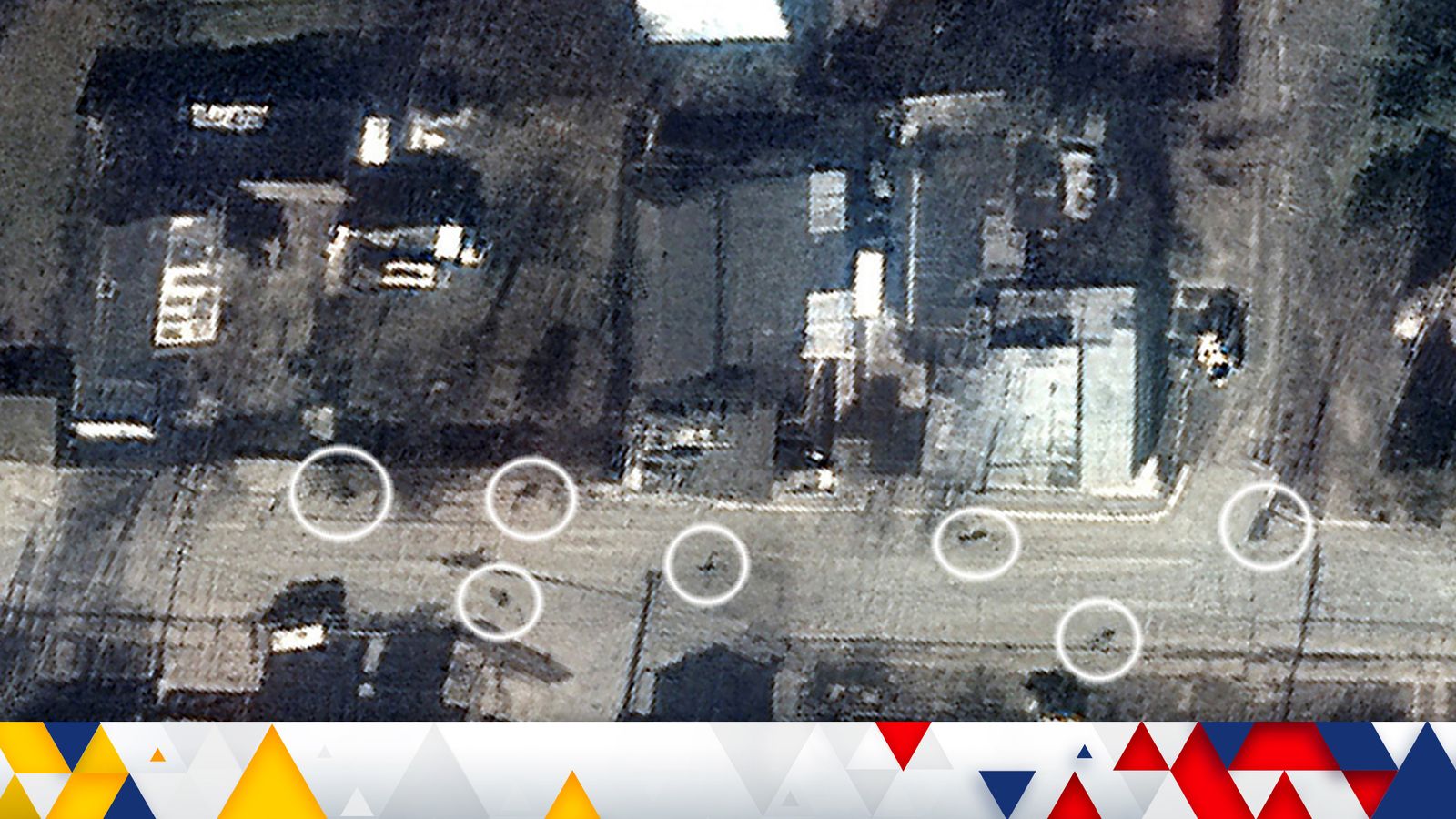
Satellite imagery appears to show at least nine bodies have been lying in a street in Bucha for weeks, disputing Russian claims their forces were not responsible for the deaths in the Ukrainian town.
Many of the bodies were found with their hands tied behind their back suggesting they were executed.
The killings in the town, which was occupied by Russian forces for weeks before they withdrew, prompted Prime Minister Boris Johnson to accuse Russia of committing war crimes.
On Sunday Russia claimed the bodies had been placed on the street sometime after their forces withdrew from the town, less than 15 miles northwest of Kyiv, on 30 March.
The new images undermine this claim.
The map below shows the site of a mass grave found in Bucha and a satellite image of Yablonska street, where bodies were seen in recent days, provided by satellite imagery company Maxar.
Comparing satellite imagery taken on 19 March, which appears to show dark shapes scattered along the road, with a video released on social media on 1 April, can help verify if the shapes are bodies and when they first appeared.
Ukraine war: What we know about the helicopter attack on an oil depot inside Russia
Ukraine war: Mobile networks being weaponised to target troops on both sides of conflict
Energy bills rebate: Average council tax bill will fall this year after Rishi Sunak stepped in to ease cost of living crisis
Below a zoomed-in view of the satellite photo shows three dark patches on the ground where bodies can be seen in a shot from the video.
In several other shots from the video shapes that appear in the satellite imagery correspond to where bodies were found after the Russians retreated.
The images below show more bodies on Yablonska street, a suburban road in the south of Bucha, with the video and satellite pictures again matching.
In a third shot from the video three bodies can be seen lying near some building materials next to a roundabout.
In the satellite imagery only one shape which appears to be a body can be identified, highlighted in yellow, although the shadowing means it is inconclusive if the others were present on 19 March.
Moving along the road to the east a final body can be identified.
The shadows from telegraph poles and the distance from the roundabout match those seen in the video, making it highly likely the dark shape sprawled on the road in the satellite image is the body seen in the video.
In total nine bodies seen in the video match the outlines of those that can be made out in the satellite imagery.
It indicates the people were killed sometime before 19 March.
This corresponds with eyewitness accounts from journalists who visited the area this week, who said the strong odour of the bodies suggested they had been killed some weeks prior.
How do we know the video is real?
The shots matched against the satellite imagery come from a video released on social media.
Sky News previously geo-located this video to Yablonska Street in Bucha by matching distinctive buildings and other markers between the video, existing satellite imagery, and Google Street View.
Multiple photographs showing the bodies on Yablonksa Street were also taken by journalists and were published from 2 April, just a day after the video was released.
Professor Michael Clarke, former director-general of the think tank RUSI, told Sky News there was no reason to doubt the veracity of the images from Maxar, an independent satellite monitoring organisation. He also hinted it might now be possible to find out who was responsible for the killings.
“Maxar have shown these bodies were lying in the street for quite a long time, when the Russians were still there,” he said.
“And yesterday, the Ukrainian government released the names of quite a lot of members of the 64th motorised rifle brigade – they were the last unit to be in Bucha. There’s an awful lot of dots out there now, and the internet community is being invited to join them up.”
The Data and Forensics team is a multi-skilled unit dedicated to providing transparent journalism from Sky News. We gather, analyse and visualise data to tell data-driven stories. We combine traditional reporting skills with advanced analysis of satellite images, social media and other open source information. Through multimedia storytelling we aim to better explain the world while also showing how our journalism is done.


